 ar
ar bg
bg hr
hr cs
cs da
da nl
nl fi
fi fr
fr de
de el
el hi
hi it
it ko
ko no
no pl
pl pt
pt ro
ro ru
ru es
es sv
sv tl
tl iw
iw id
id lv
lv lt
lt sr
sr sk
sk sl
sl uk
uk vi
vi et
et hu
hu th
th tr
tr fa
fa ms
ms hy
hy ka
ka ur
ur bn
bn mn
mn ta
ta kk
kk uz
uz ku
ku
gnss settlement sensors
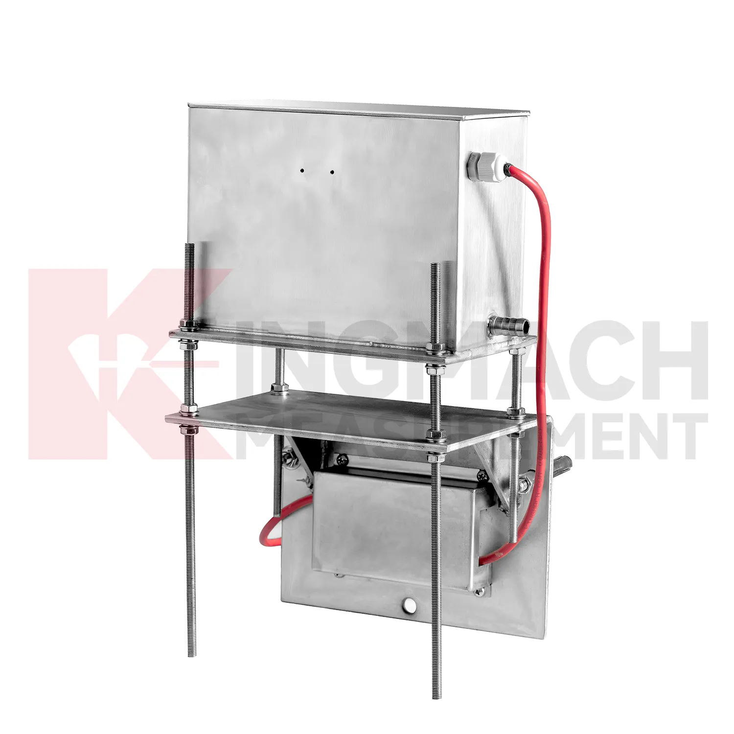
Selecting Kingmach gnss settlement sensors begins with the scale and shape of expected movement. A single embedded point, a hydrostatic comparison line, a wide-range profile, and a magnetic ring borehole answer different questions. JMDL-47XXAT covers 100 mm to 400 mm embedded settlement. JMDL-62XXADT and JMQJ-62XXADT provide 0.01 mm hydrostatic resolution for smaller vertical changes. JMYC-62XXAD covers 500 mm to 4000 mm with 0.1 mm resolution and 0.2%FS accuracy for larger movement. JMCJ-1003/1005 provides plus or minus 1 mm depth reading for magnetic ring settlement and water level checks. Selection should consider whether the structure will remain accessible, whether groundwater is part of the risk, whether automatic collection is required, and whether the reference point can remain stable for the full observation period. A short-range high-resolution instrument is not automatically better if the site may move beyond its travel. A large-range system is not always best if the project needs very small early warnings.

Application of gnss settlement sensors
Building projects use gnss settlement sensors when a foundation, basement, column line, retaining wall, or adjacent ground area needs a dated vertical movement record. The work often starts before the permanent structure is complete: excavation, dewatering, pile work, concrete loading, and backfilling can all change elevation patterns. Kingmach JMDL-47XXAT is relevant to pile foundation settlement and base uplift in deep foundation pits, while JMDL-62XXADT or JMQJ-62XXADT hydrostatic sensors can compare several building points from one reference. A useful layout may follow a gridline instead of only the most visible cracks, because differential movement across a structural bay is often more important than one isolated value. The record should connect each channel to a floor level, nearby column or wall mark, construction date, water condition, and visual inspection note. If one side of a basement drifts while another remains steady, the trend can guide more focused review. For occupied buildings, stable wiring, protected cabinets, and clear point labels matter because readings may continue through many inspection cycles.
The future of gnss settlement sensors
The future of gnss settlement sensors will include cleaner digital handover records. Settlement monitoring often lasts longer than the construction team stays on site, so owners need more than a table of values. A useful handover file should include model, serial number, range, reference point, tube route, ring depth, baseline, installation photo, cable tag, borehole number, and first stable reading. Kingmach products such as JMDL-47XXAT and JMCJ-1003/1005 especially benefit from this because embedded rods, magnetic rings, anchors, and borehole readings may be hard to inspect later. When that information is stored with the curve, maintenance teams can understand why a point was installed and how its settlement should be interpreted years later. Future records should make the instrument history as visible as the measurement itself, so old readings can still be trusted after staff changes, repairs, and new construction stages.
Care & Maintenance of gnss settlement sensors
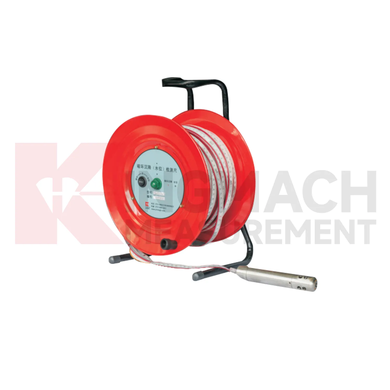
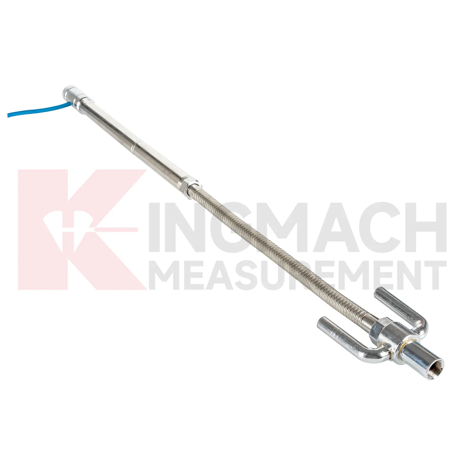
Magnetic ring gnss settlement sensors need consistent field habits. For JMCJ-1003/1005, record borehole number, ring depth, water level depth, tape mark, operator, date, battery status, and previous reading each time. The magnetic ring function relies on electromagnetic induction and audible or visual indication, while water level detection responds when the probe contacts water. Different operators should use the same borehole orifice reference mark and the same tape handling method. After field work, clean the probe, dry the reel, inspect the tape cable, check the battery, and note any weak alarm or rough movement in the borehole. Layered settlement data depends on repeated depth reading discipline. A small careless change in reference mark can look like soil compression, so field notes should be plain, dated, and easy to audit.
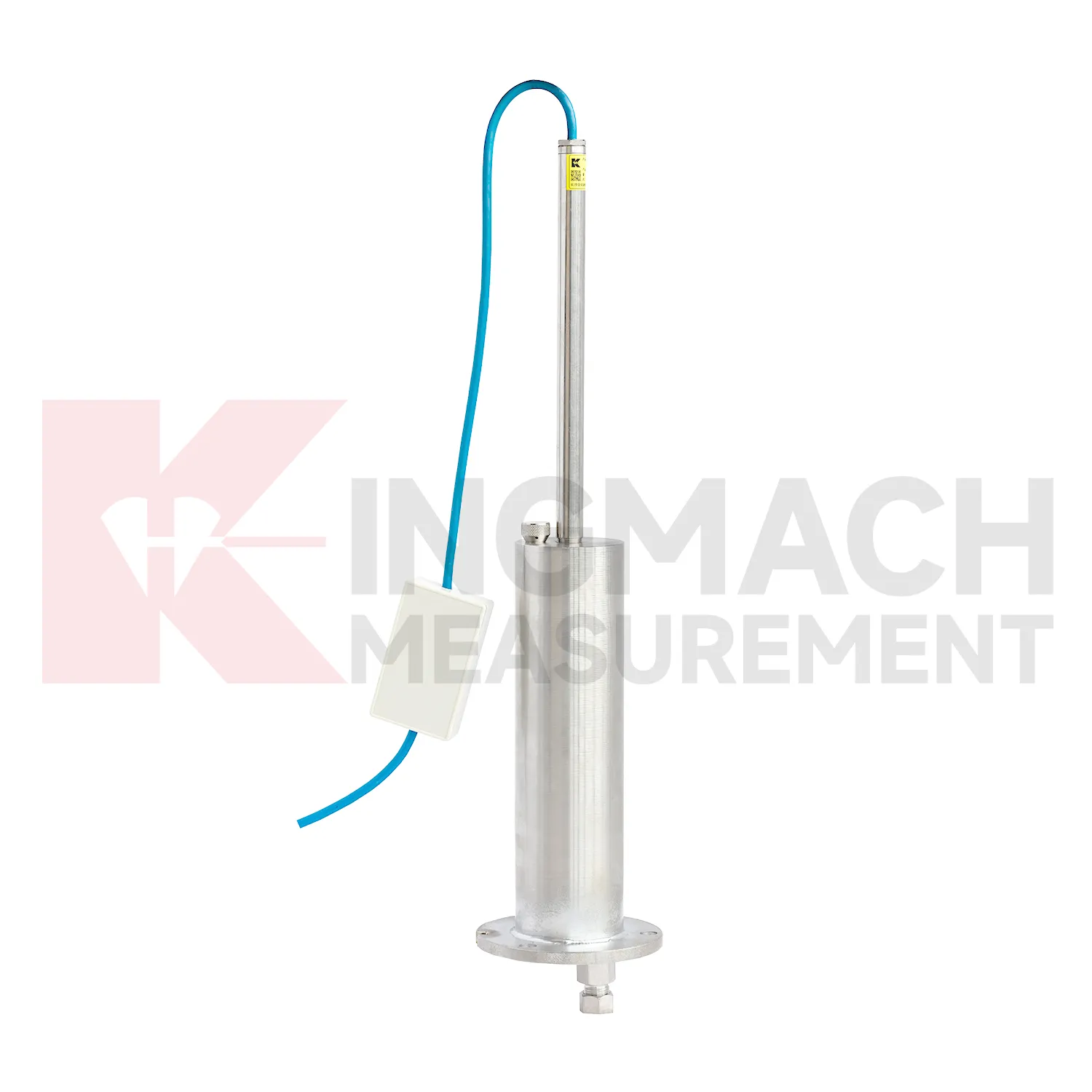
Kingmach gnss settlement sensors
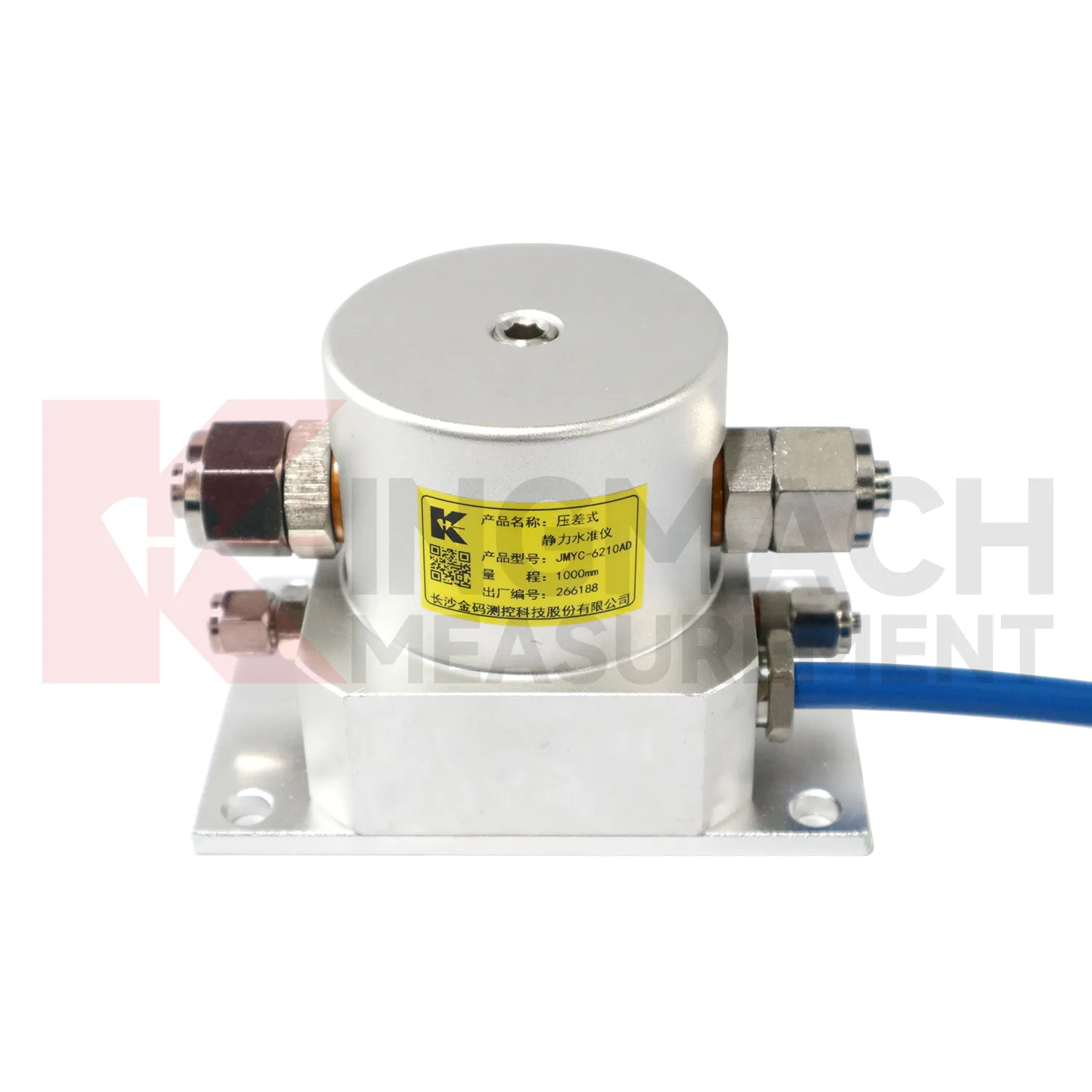
Hydrostatic gnss settlement sensors are useful when several vertical movement points must be compared against a reference rather than read as isolated values. Kingmach JMDL-62XXADT and JMQJ-62XXADT use connected liquid paths and digital output to monitor vertical deformation in structures such as bridges, dams, tunnels, large buildings, and subgrades. The JMDL-62XXADT lists 50 mm, 100 mm, and 200 mm ranges with 0.01 mm resolution and RS485 output. The JMQJ-62XXADT micro range hydrostatic level sensor lists 50 mm and 100 mm ranges, 0.01 mm resolution, RS485 signal, and IP68 protection. These products are most useful when the tube route, reference point, cabinet, and baseline are documented clearly. If the reference is unstable, every curve downstream becomes harder to trust. A good point record also names the reference location, installation elevation, data channel, and maintenance access so later readings can be checked without guesswork. A good point record also names the reference location, installation elevation, data channel, and maintenance access so later readings can be checked without guesswork.
FAQ
Q: What are gnss settlement sensors used for?
A: They measure vertical deformation such as foundation settlement, subgrade settlement, embankment heave, tunnel bottom uplift, dam settlement, bridge deflection, and building settlement.
Q: Which Kingmach models are related to this group?
A: Common models include JMDL-47XXAT, JMDL-62XXAT/ADT, JMQJ-62XXADT, JMYC-62XXAD, and JMCJ-1003/1005.
Q: What is the difference between single-point and hydrostatic monitoring?
A: Single-point gauges measure settlement at a specific embedded point, while hydrostatic systems compare several points against a reference level through connected liquid paths.
Q: Can the readings be collected remotely?
A: Yes. Several Kingmach hydrostatic and settlement instruments support RS485 output or automatic acquisition systems for remote collection.
Q: Why is the reference point important?
A: Settlement is often calculated relative to a reference. If the reference changes or is poorly documented, the whole settlement curve can become misleading.
Reviews
James Thompson
The tiltmeters and accelerometers are very sensitive and provide precise data. Perfect for our structural health monitoring system.
Andrew Lee
The visualization software is intuitive and powerful. It helps us analyze monitoring data efficiently.
Latest Inquiries
To protect the privacy of our buyers, only public service email domains like Gmail, Yahoo, and MSN will be displayed. Additionally, only a limited portion of the inquiry content will be shown.
Ava***@gmail.comAustralia
Hi, I am looking for reliable tiltmeters and accelerometers for structural health monitoring. Please...
Sophia***@gmail.comUnited Kingdom
Good day, we need environmental monitoring sensors including temperature, humidity, and wind sensors...
Related product categories
- Wide-Range Differential Pressure Hydrostatic Level Sensor
- Inductive Frequency-Modulated Hydrostatic Level Sensor
- water level gauge
- water gauge water level gauge
- water gauge level
- gauge water level
- Magnetic Ring Settlement Water Level Gauge
- Optical Deflection Monitor
- Tilt Sensor
- Deflectometer
- Micro Range Hydrostatic Level Sensor
- Single-point Settlement Meter